Holland Land Company Records, UC Davis Special Collections
50 Features of Special Collections: Holland Land Company Records
With the recent rains, the opening of the Sacramento Weir, and the flooded Yolo Bypass, we thought that it was fitting to feature the Holland Land Company Records this week.
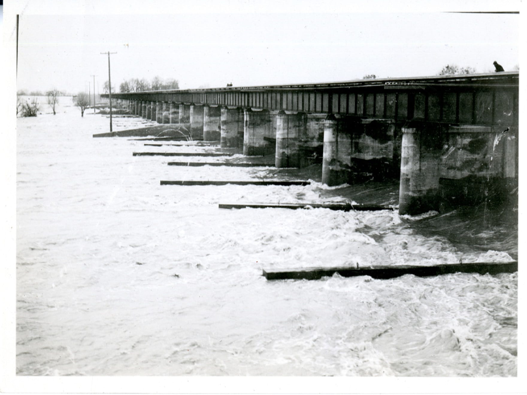
The following information is drawn from the collection finding aid. Be sure to check out the photographs below which show the Sacramento Weir as it looked almost exactly ninety-two years ago to the day.
Operations headquarters for the Holland Land Company were in Clarksburg, California, located at the northwestern edge of the Sacramento-San Joaquin River Delta. Situated in the southeastern corner of Yolo County, Clarksburg is on the west side of the Sacramento River about fifteen miles south of and across the river from the city of Sacramento. There was no bridge across the Sacramento River near Clarksburg (until the Freeport Bridge opened in 1929), so Clarksburg area residents depended on ferryboats for river crossings. Clarksburg was also physically isolated from the rest of Yolo County by miles of tule marshes. Clarksburg, Lisbon, and Merritt Island were all part of Merritt Township, Yolo County.
During the second half of the nineteenth century, floods were a serious problem for Clarksburg area residents. They built their homes on high ground and on pilings to protect themselves from rising waters, and some lived in houseboats. Early settlers made their living by fishing, hunting wild ducks and geese, cutting wood, and doing their best to raise crops and cattle in the flood-prone Delta marshland. Roads and bridges were either in terrible condition or non-existent, so through the first two decades of the twentieth century, the Sacramento River was Clarksburg’s main transportation route. Passengers and freight were carried up and down the river on the many riverboats that ran on regular schedules between San Francisco and Red Bluff. Most farm produce left Clarksburg by boat. Elk Slough along the western edge of Merritt Island was also a busy channel for barges.
In the 1860s the California Legislature passed laws authorizing the formation of reclamation districts, which were to be units of local government organized and financed by the residents of an area to build levees along the rivers to keep the water out, and to build canals in the basins to drain the seepage. In 1870, Merritt Island landowners formed the first reclamation district in Merritt Township, Reclamation District (R.D.) 150, which built eighteen miles of levees, around Merritt Island. Organized in 1877, the Lisbon District, R.D. 307, built fourteen miles of levees around land north of Merritt Island to Babel Slough. Though the levees built by these pioneering reclamation districts protected the land against some of the rising waters, the area still suffered from flooding.
It was not until 1911 that the California Legislature adopted the Sacramento Flood Control Plan. The plan called for federal and state governments, reclamation districts, and private companies to cooperate in controlling flooding in the Sacramento River. They would do this by building continuous levees along the entire length of the river, enlarging the mouth of the river, removing debris from the Sacramento and its tributaries, and creating by-passes in the Sutter and Yolo basins to divert excess water from the main channel of the Sacramento River. The large profits that could be made by reclaiming and selling fertile farm land, adjacent to the Sacramento River but protected from flooding, attracted investors to reclamation projects. Many major projects commenced circa 1911 and were completed by the early 1920s, resulting in extensive and effective flood protection for Delta land.
In 1911, Isaac B. Parsons of the Bank of Hayward began buying land in the vicinity of Clarksburg for a group of men who were to form the Netherlands Farms Company. These men petitioned for the formation of a reclamation district, and in 1913 the California Legislature created R.D. 999. Financial difficulties and the outbreak of war in Europe, led to the dissolution of the Netherlands Farms Co. on March 3, 1917.
The Holland Land Company, incorporated on May 26, 1916 with three million dollars in order to protect and profit from the investment made by the Netherlands Farms Co. By the end of 1916, the Holland Land Co. paid off the debts of the Netherlands Farms Co. and began the work of reclaiming the Holland District (R.D. 999), including Clarksburg. The Holland Land Co. divided its capital stock of three million dollars into thirty thousand shares worth one hundred dollars each. In the 1920s, land owned in Solano and Yolo counties by the Holland Land Co. exceeded fifty thousand acres and was bounded by Ryer Island to the south, the Yolo Basin to the west, Elk Slough to the east, and the Lisbon District (R.D. 307) to the north.
When the Holland Land Co. began its reclamation work in 1916, the ground of the Holland District was wet and soft and covered with almost impenetrable tules growing seven to twelve feet high. No roads and levees existed. Reclamation of the Holland District took about two years, cost $2,500,000, and involved using heavy equipment including clamshell dredges, draglines, ditchers, and tractors. To remove excess water from farmland in winter and to provide water for irrigation in summer, the company built thirty-five miles of levees, 150 miles of canals, one 175,000 gallon-a-minute main pumping plant, and eighteen subsidiary pumping plants. The enormous leather-belt-driven pumps at the main pumping plant of R.D. 999 were installed in 1917. The Holland Land Co. also drained Big Lake and constructed twenty-five miles of roads, one hundred bridges, and over ninety farm buildings.
In September 1919, the Holland Land Co. formed an additional company, the Holland By-Pass Company, to enclose with levees nearly three thousand acres in the Yolo Bypass. Circa March 1924, when the Holland By-Pass Co. accomplished its purpose, the company was dissolved and all its assets were transferred to the Holland Land Co.
After the levees were built, the Holland Land Co. prepared its land for planting by using teams, plows, and horse-drawn Fresno scrapers. Circa 1918, the Holland Land Co. began planting crops to sell for cash and to set an example for prospective buyers and tenants. Formerly Superintendent of the Netherlands Farms Co., Gus Olson (1888-1970), an engineer and General Manager of the Holland Land Co., farmed successfully on the newly reclaimed land at the company’s headquarters. Under Olson’s direction, the company experimented with a wide variety of crops including alfalfa, asparagus, barley, beans, celery, lettuce, potatoes, sugar beets, and wheat. The company also established a nursery of five hundred thousand fruit and shade trees, and more than one hundred thousand fruit trees were planted in the district. Pear trees were particularly well-suited to the Clarksburg area.
In the spring of 1918, once the Holland Land Co. had completed much of its reclamation work and the Clarksburg area was protected from seasonal flooding, the company began developing and marketing its land. Most of the lots it sold were for farms and residences, but some were for commercial enterprises. The company’s policy was to sell a buyer not more than three thousand acres, at a minimum of $250 per acre, with a ten percent down payment and ten annual payments. The Holland Land Co. sold its land holdings off quickly and paid its first one dollar dividend to its stockholders in 1922. It continued to pay dividends even during the Great Depression years. On December 23, 1942, with all of its land, in private hands and maintenance of the reclamation system the responsibility of R.D. 999, the Holland Land Co. was dissolved
The Holland Land Company Records span the years 1909 to 1953, but the bulk of the materials date from 1916 to 1942. The collection consists of minute books, scrapbooks, and photographic materials. Five of the minute books were created by the Holland Land Co., and one is the work of a subsidiary, the Holland By-Pass Co. Minute books hold articles of incorporation, by-laws, annual reports, minutes of stockholders’ meetings, and other legal and financial documents. The three scrapbooks contain clippings, flyers, and other materials promoting the Holland Land Co., its properties, and California agriculture in general. The photographs contained in the Holland Land Co. Records are rich sources of information about Clarksburg, California history and land reclamation and agriculture in the California Delta region during the early part of the twentieth century. Included are numerous photographs of Clarksburg area buildings, people, crops and fields, waterways, modes of transportation, hydraulic facilities, and land reclamation and agricultural equipment.
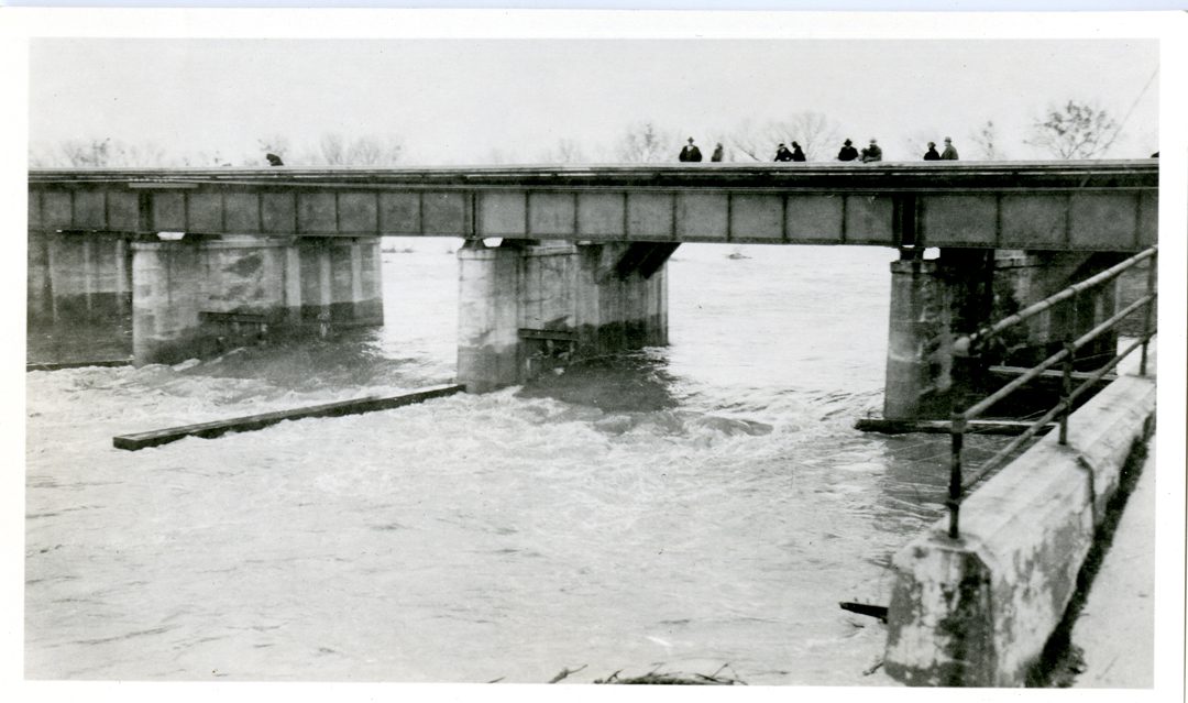
Sacramento Weir, February 7, 1925
Holland Land Company Records, UC Davis Special Collections
Sacramento Weir, February 7, 1925